Adventures must be done!

Zindlenspitz (27.09.2009)


Roman had come up with an idea for a little day hike, however, the military fraction of our team opted to make it a bit harder. Turns out that even so, it was a bit longer and wilder than some expected ...

As it was quite close to Zurich, we had a lazy, civilian start in the morning and met at Zurich main station. A bus took us on the second leg of this journey to Innerthal, from where we started tramping. First along the lake, then ascending through forest and over pastures.


Tramping through mixed alpine forest

When we left the tree line, our destination towered above us, looking formidable and in-ascendable from this point.

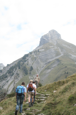
The Zindlenspitz in the hazy background

The weather was hazy and cloudy and most of the surrounding landscape remained hidden. We had however a good view over some vast limestone slope in the vicinity of the Zindlenspitz.


Limestone formation to the South (Lachenstock, 2027m)

The final ascent was steep and the last few metres led along a ridge line to the summit.


Along the ridge towards the summit.


The last few metres!

We ate our lunch and then proceeded to locate a geocache, which was discovered by Hanna after quite some combined effort. Most of the team had never seen a cache and was enthusiastically looking at the logbook and fingering some of the trashy holdings. However, there was also a red dragon with a travel bug tag, which we took along to figure out where it had come from and what its mission might be. Turns out that it wants to stay in Switzerland but had already travelled a wee bit around the country:


Trail of the travel bug, stop number 18 is the Zindlenspitz where we picked it up.


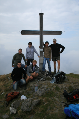
The team on the summit (2097m).


The downhill trail was graded a bit more difficult and I was stoked to see it following a sharply defined ridge!


Negotiating a short scrambling section.


On the ridge.


Hanging on and having fun.

Soon the exciting part was over and a hiking trail of normal gradient led further downhill. We had a look at the map and figured that a possible way to get back to the bus station involved a section called the 'Bear Path' (Baerenpfad). Surely, the track was somewhat unclearly marked on the map, but you get that in the mountains. It was decided to go for it, and it proved to add some more adventure to the trip. Had it not been for the scarce and faded markings on some trees and rocks, one might have called it bushbashing.
Michael stated that things could be worse: "There could be stinging nettles and stuff!" - 'Shut up!!!' the others protested, only to find some nasty nettle field fifty metres later!


Trying to get a sure footing on slippery and wet grass.


Another cable (the crew is delighted!)

Pretty everyone was happy to reach a proper trail again which brought us swiftly back to the bus station, where we had enough time for some after action review in a restaurant. It was concluded that it had been a neat trip, although, next time we might get up a bit earlier!

Cheers to the team

Andy


Bisisthal - Linthal Tramp (19-20 Sept 2009)

Aye, yes, guys, long time no blogging, which does not mean I was lazing around and not being out and about! But it's much easier to write about a weekend than about a few weeks, thus, I'll just gonna cover the tramp Marcel and I just did over the weekend.

The idea to do this tramp was mainly because I had a map of the region and the area seemed quite promising.
Situated in the middle of Switzerland, this part of the Alps was yet unknown to me and it was the business of this tramp to go and explore. Naturally, we took along the tarp, stove, food etc to be independent of any huts.
I did the planning of the route using GIS, because it is well known that the digital age is so much more efficient. Well, in fact, I reckon it took me longer to sort out all the little problems, than had I done it the old fashioned way. However, the resulting map looks neat and the time schedule is way detailed!

Topomap showing the trail

We started around 10am and were soon making our way through a forest with trillions of ants crawling on the path. A steeply inclined trail took us towards the tree line and we were sweating profusely due to the high humidity. Another climb brought us from a valley full of cows with enormous bells up to a jumble of limestone rocks. At the other end of this undulating field of boulders came an awesome sight: a great plain stretched all the way to the next mountain range, which seemed a long way off and immensely steep.


Marcel consulting map and GPS with the next range in the background


Looking towards the next range

I whipped out my camera and told Marcel to keep going, as I wanted to document his advance over the plain. It was clear that the hazy conditions combined with looking towards the sun resulted in a distortion of distances. The plain that seemed some kilometres wide was crossed in a matter of minutes!


Marcel on the big plain (the little dot approaching the other side of the plain)


Cliffs above the plain


View towards the head of the valley

I then followed Marcel and had a delightful stroll over the expanse of swampy ground towards the other side, where we found a little rivulet to top up our water bottles before the ascent to a pass that would lead us to another valley. As usual, we quickened our pace when approaching the top as we longed to see what lay beyond!


On the pass with the Glattalp valley behind us

We had a few minutes rest, enjoying the view and marvelling at the mix of clouds and sunshine towards the West. Then we tramped on, first traversing and then descending to the confluence of a few little, almost dried-out streams where we found running water and a flat, dry place to set up camp. It was still quite early and we enjoyed a cuppa and had a good yarn.


Clouds shroud the peaks in the West


Our camp


Having a cuppa and watching the clouds roll in


Another cup of tea, some snoozing and suddenly it got somewhat chilly with the sun gone and fog reducing the view drastically. We retired to the tent and prepared dinner: pasta with tomato soup and cheese; an all time classic.
Just when we were ready to dig in, a light drizzle started.
"Ah, wonderful!" - 'What a timing!'
With delight we listened to the sound of rain on the tarp.
Alas, the rain soon stopped and the night passed without any further natural lullaby.

The next morning dawned quite clear but on the next pass hung clouds. We had a porridge for breakfast, which was quite good, despite the fact that Marcel kept sneering at my promises of '... this will be a porridge like no other!'
A traverse and steep climb brought us up to the saddle (2395 m asl) where a cold wind was blowing and we soon started the descent on the other side.

Steep descent from the pass

From there, just about 3 kilometres horizontal and 1800 metres vertical separated us from our goal: the train station where the chances to get a beer were extraordinarily high, for it was a warm day again!

A most excellent 2 day trip and in unison, we lifted our pints and declared: "Tramping rocks!"