Maggia Valley to Formazza Tramp (8. - 12. Oct 2009)
October is traditionally the time for the yearly autumn tramp.
This possibly needs some further explanation: autumn IS the best season of all; there are the beautiful colours of senescent leaves, the clearness of air and plenty of berries and nuts. Splendid!
The planned route led from the Maggia Valley towards Binntal. But where we got, we shall see in due course ...
Day 1
We left Zurich in the later afternoon with the goal of reaching the starting point of the tramp that very evening. In this we succeeded and the tent spot we had discovered the year before served us well again. Soon a merry fire was crackling and the tarp set up, as some rain seemed imminent. Some water was boiled and tea served soon after. Then Reto and myself relaxed on the shingles close to the fire and waited for Marcel, who had taken a later connection, to find our camp. So presently he did and our party was complete.
Day 2
There was quite some rain during the night, the best lullaby I can think off, well, if it hadn't been for a sloppiness on my account when putting up the tarp. There was a considerable pool starting to fill on top, till I got up, emptied it and retied the tarp in a smarter way, allowing the rain to flow off freely.
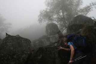
The morning started dry but extremely foggy.
We followed the road for a while, then reached a stone bridge arching gracefully over a stream. Here we left civilisation behind us and soon after lost the path. On we went, boulder scrambling uphill, trying not to slip on the soapy lichen covering the wet rocks.

Marcel on the old stone bridge leading into the wilderness.
 Up we go!
Marcel consulted his GPS and confirmed that 'we were on the trail'. A comforting thought to those not yet used to bushbashing and boulder hopping!
A short while later, we came indeed upon a path that was even marked and progress got somewhat swifter although less interesting.
This was soon made up for, as we ascended into dense mist that shrouded the surroundings, creating a mysterious atmosphere. Truly, there is a wonderful aspect about such weather.
 Tramping in diffuse conditions.
 Beech trees in the mist.
 Reto and Marcel starting to disappear.
It got darker by the minute and not before long a drizzle started that soon turned into steady rain and made us don the rain jackets. The rain ceased in time for lunch, which was kept shortish as our bodies were cooling down given the dampness and lower temperature regime.
At was at this altitude that we came upon the richest blueberry grounds we had ever seen and we spent some time digging in. Most delicious!
The trail vanished after the last derelict shepherds buildings or we could not spot it due to the fog and rain, that had inconveniently regained in strength soon after we left the main tree line behind us. These circumstances led to some more bushbashing through dripping wet Rhododendron hirsutum and other shrub like plants. At last, brown alpine pastures replaced the bush and we got a few glimpses of the mountain pass above us.
The trail vanished after the last derelict shepherds buildings or we could not spot it due to the fog and rain, that had inconveniently regained in strength soon after we left the main tree line behind us. These circumstances led to some more bushbashing through dripping wet Rhododendron hirsutum and other shrub like plants. At last, brown alpine pastures replaced the bush and we got a few glimpses of the mountain pass above us.
 Marcel with the pass guessable in the background.
We crossed the pass and pushed on, by now it was getting really wet and even chilly, after all, we had reached an altitude of 2300 metres after ascending 1900 metres. Marcel and I decided on the spot, that we would not tramp on to the originally planned camp site near a lake but find a suitable site as soon as possible. In this we prevailed, although finding a spot that was not too wet took some scouting. I extracted the tarp and we had soon set it up and crawled in.
The border between hypothermia and utter comfort can be crossed in an instant if you don't know what your doing or have the wrong gear. As things were, the only sensible thing to do was take off the wet clothing, put on the longjohns and spare shirts, blow up the matresses, stuff the sleeping bags into the bivvy bags and slip in. Then we started the stove for a nice cuppa and life was pretty comfy and agreeable again. Soon, we held steaming mugs of cappucino and nibbled some biscuits and chocolate. Still, it was raining, which was most pleasurable, given that the tarp was waterproof.
Me: "These cookies are AWESOME!!!"
Marcel: "Things are going extremely well!"
 Reto studying the topomap.
After teatime the rain reduced to a drizzle and we took the chance to take a leak, get some new water from the nearby rivulet and take in the vista.
Cooking and eating were the last main actions of this remarkable day and soon after we snuggled into our sleeping bags and listened to the rain, just in time starting again with curiously singular big, heavy drops, gradually leading to steady downpour again.
Day 3
Day 3 dawned rainless and calm.
After morning tea followed by porridge, the tarp was collapsed and all gear stowed in the packs. By now, the clouds broke up and wonderful sunshine reached the Earth. Not to diminish the qualities of a rainy day, but sunshine is quite nice once in a while as well!
It was not very far to the next pass, from where we had planned a traverse to reach a mountain lake that had been the original destination of the previous day. It was again a pathless place, but while on the ascending side, alpine pastures interspersed with rocks dominated, a wild jumble of boulders of all sizes met us on the other side.
An examination of the topography resulted in abandoning the traversing plan as there were steep, glacier polished rock slabs that would have been challenging enough in dry conditions but were much too risky on this particular day. Thus, we boulder-hopped downhill and then scrambled up a grassy slope to reach the lake.
We had a hurried lunch at the lake (it was raining again) and tramped on towards the next pass, requiring our boulder hopping experiences once more. Marcel and I were most accomplished in this sort of travel and drew ahead, keen to see what lay beyond.
 Steaming mountain ranges.
The weather was quite varied, including brief glimpses of sunshine, mist, wind and rain.
On one of the slopes we met two curious cows that were presumably after salt and started to slobber all over my backpack, which I had taken off to put on my rain trousers.
On one of the slopes we met two curious cows that were presumably after salt and started to slobber all over my backpack, which I had taken off to put on my rain trousers.
 I'm attracting the attention of two cows ...
Finding a camp site was not that easy today, as we had descended below the tree line to have the chance of a camp fire. We finally found a likely spot that needed quite some terrain reforming (moving boulders and building platforms to prevent us from slipping down the slope). While I was busy with terra-forming, Marcel and Reto occupied themselves with building a fire. No easy task after the heavy rains. I joined them a while later in the job of peeling the wet bark of branches and producing dry splinters.
It took considerable time, but then we had a roaring fire, warm enough to sit barefeeted, which was a relieve as the boots were soaked.
Now was the chance to roast some chestnuts we had picked up in valley on the first morning. Delicious!
Day 4
Day four started out as a stunner; not a single clould was to be seen!
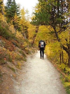
After breakfast cooked on fire, we descended further into the Valley of Formazza, traversed a mixed beech and coniferous forest and ascended via a dammed lake to a further pass, where we arrived in the afternoon.
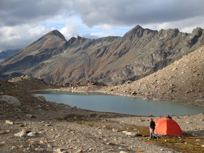
From here we took a direct route over glacially formed terrain towards a bivvy.
We arrived at the bivvy in the later afternoon. It lay just a few metres past a pass and a fierce wind was blowing, causing us to retreat into the hut despite the sunshine. The bivvy was a a concrete construction and pretty cold inside, 6.5 degrees, but it kept out the windchill.
At dusk a weather change seemed imminent with clouds rolling over the next pass and quickly covering the hemisphere above us. We had mobile connection and figured out that there would be snow tomorrow. To cope with all eventualities, we developed an alternative route, leading back into the Valley of Formazza and allowing a swift retreat, should worse come to worst.
A few snowflakes were already blown by our hut when we retreated to our sleeping bags.
The night was the coldest yet off all on this trip; the building was a formidable fridge!
Day 5
We got up at 6am, prepared breakfast and look out of the door. There were about 10cm of snow and the view was down to about 20 metres. Reto was promoting the swift descent via the alternate and we finally consented to that, as the original route would have involved another pass and no one knew what the current weather might evolve into.
We were therefore on our way in the break of dawn, carefully moving among the snow covered rocks.
 Descending from the bivvy in the first snow of the season.
Hiking conditions were actually quite good and we progressed nicely. The snow added some new flavour to the landscape and I enjoyed the darkness and stillness imposed by the fresh snow.
Tramping high above the lake, lying grey and forbidding below us, added to the wildness of the land shrouded in fog and drifting sheets of snow flakes.
Tramping high above the lake, lying grey and forbidding below us, added to the wildness of the land shrouded in fog and drifting sheets of snow flakes.
 Snow starts to accumulate at even lower altitudes while we descend.
The path from the end of the lake down into the valley was neither exciting nor spirit lifting in any sort and I will pass over that bit. Suffice it to report that we found a restaurant in the village of Valdo where we ordered coffee and croissants.
We then had to pass a few hours in that place, whiling away the time till the next bus left in direction of Domodossola. While Reto rejoiced in shopping for regional groceries such as Prosciutto di Parma, Marcel and I felt downhearted and grumpy because we had failed in reaching our planned destination and had unfinished business in these parts of the Alps.
We grumbled and dratted as we were forced to join the shopping frenzy by our comrade, sneering at the cuckoo clocks and other touristic crap on sale.
Getting a lunch in a nearby pizzeria on the other hand was not that bad after all.
Still, I cheered up when being able to board the bus and leave the place behind.
The weather cleared up as we proceeded South and in Domodossola ample sunshine prevailed, allowing the savouring of an icecream (excellent stuff down in Italy).
We shall return!!!


