Climb? Tramp SSW! (12-13 June 2010)
Marcel and myself had come up with the idea of climbing the usual ridge line on the Pilatus again. However, when we met in Lucerne, the weather was rather overcast and by the time we arrived in Alpnachstad it started to drizzle. Bad conditions for a climb on limestone.
We therefore adapted our plans and started to tramp uphill; after all we had all the gear needed to camp out.
On the way up we met a guy from Singapore and were pleased to hear that he had decided to hike up to Pilatus despite the short time frame he stayed in Switzerland.

Lee Kun Liang and me at the half-way point.
We came across a large number of Alpine Salamanders (Salamandra atra) along the way, they obviously liked the moist conditions. Just when editing this blog entry, I figured out that there is a website to log salamander sightings; here's my entry http://alpensalamander.eu/blog/Salamander_Report4/map_function_foto10.php?11&46.95448061777255&8.284378051757812&4&
We covered the 1600 metres ascent to the summit of Pilatus in a good 3hrs under constant drizzle, then decided to continue along the ridge line.
Soon after the weather improved; the rain stopped and gradually the mist started to lift.

Looking down from the ridge.

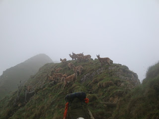
Herd of ibex (Capra ibex) blocking the path.
 Marcel disappearing in the mist.
 Unexpectedly wild landscape.
 Approaching a snow traverse in the gully ahead.
 Marcel tackling a short via ferrata passage.
 Rock Ptarmigans (Lagopus muta)
 Only a good hour to Tripoli(s)?
 Looking down on Oberwald
 Marcel disappearing in the mist.
 Unexpectedly wild landscape.
 Approaching a snow traverse in the gully ahead.
 Marcel tackling a short via ferrata passage.
 Rock Ptarmigans (Lagopus muta)
 Only a good hour to Tripoli(s)?
 Looking down on Oberwald
After descending from Widderfeld, we came across a moor like landscape, reminding us of Scotland. Here, we had a short break, then decided to head further on:
"Bearing South-South-West!"
"Bearing South-South-West!"
 Mittagguepfi (1916m asl)
 Looking West from the Mittagguepfi. This feels like the Northern edge of the Alps!
From Mittagguepfi we followed a trail with some cables, leading us to Tripoli hut. There, we found a bunch of people working around the hut and also yummo cake and coffee, which were offered to us, followed by some sausage we had to sample as well!
Superbe break!
Superbe break!
 Tripoli Hut.
From Tripoli, we tramped up to Staefeliflue (1922m asl), where we located a geocache, then we descended in search of a passable camp site.
 Descending from Staefeliflue.
 Schimbrig 1815m asl
By now we had walked off our map sheet and were navigating on sight. At the end, we found a fair camp site at the edge of a forest with lots of fire wood and two rivulets close by.

We were happy to setup camp, light a fire, prepare tea and once more marvel about today's unexpected adventures.
There was a bit of rain during the night, quite pleasant.
By the morning, Marcel had figured out our position using his iPhone: we were in the Entlebuch, a part of Switzerland being notoriously wet!
Indeed so. There were quite a lot of slugs around, appearing in the most irksome manner. Rather disgusting little critters.
 Slug on my platypus bottle.
 Little slug sliming along on my platypus mouth piece.
Luckily, I was not that thirsty during the night!
 Cooking tea in the morning.
Trail planning proved difficult without a topomap and we to used Google maps on the iPhone. We resolved to tramp to Glaubenberg, another pass we knew from previous adventures (igloo building a few years back). However, the path up there was mainly along the road, which did not cheers us up very much at all. In any case, we made it right for lunch!

Profile of day 2.

Our 2 day tramp on Google Earth.
Excellent adventure!
A post trip map study shows however that there would have been a lot of good trails for the second day, heading SW!
We shall return for more adventures!


